

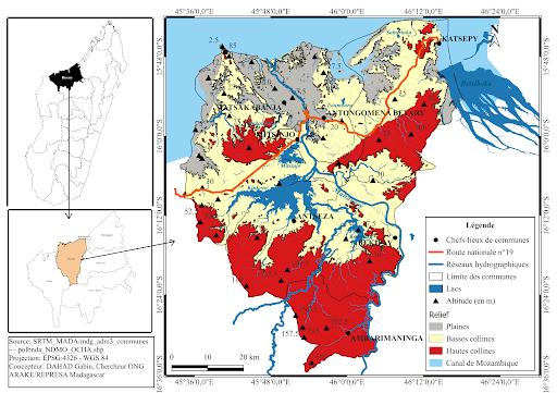
| Overview of Mitsinjo District | |
|---|---|
| Location | Western part of Madagascar, Boeny Region |
| Geographic coordinates | Latitude: 16°36’0.0’’ to 15°48’0.0’’ South Longitude: 45°36’0.0’’ to 46°24’0.0’’ East |
| Altitude | Generally low elevations |
| Agricultural potential | Well-suited for various types of crops |
| Geographic factors of vulnerability | - Proximity to the Mozambique Channel - Abundance of hydrographic networks - Exposure due to location |
| Risks | Highly vulnerable to cyclones and flooding |
The district's topography is divided into three major zones: plains, low hills, and high hills. The first two are mainly found in the coastal areas, especially in the municipalities of Matsakabanja, Antongomena Bevary, and Katsepy. The low hills also extend into the municipality of Mitsinjo, as well as parts of Bekipay and Antseza. These lowlands can drop to as little as 2 meters above sea level near the coast but rise to approximately 20 or even 30 meters further inland.
In contrast, the high hills occupy the interior areas, particularly the municipality of Ambarimaningana, where the peaks can reach up to 200 meters in elevation. They also extend into the southwestern part of Katsepy, the southern areas of Bekipay, Antseza, and Mitsinjo, and a small part of Matsakabanja, although altitudes in those parts are more moderate, around 100 meters.
To reach the area, one must first cross the sea from the city of Mahajanga, then take National Road No. 19. This road, which is entirely unpaved, makes access particularly difficult—especially during periods of heavy rain. Flooding and cyclones regularly damage infrastructure such as roads and bridges, isolating communities. This situation significantly hinders the delivery of aid, humanitarian assistance, and disaster recovery efforts.
The Sakalava are the region’s indigenous people. For a long time, populations from southeastern Madagascar have settled in the area, particularly in the lowland zones of Matsakabanja and Antongomena Bevary. This migration aimed to boost the agricultural and industrial labor force, especially for the Ouest Sucre company (formerly SIRAMA).
Today, there is a strong presence of migrants from the south who farm land and forests while also engaging in small-scale trade. These populations tend to settle in the most remote areas. Other groups, such as the Tsimihety, have also started to integrate into the region, although their numbers remain relatively low.
In Mitsinjo, agriculture is the main activity for the vast majority of the population. In the lower areas, especially in Matsakabanja and Antongomena Bevary, rice and sugarcane cultivation dominate. The latter is especially encouraged by the presence of the Ouest Sucre company, located in Namakia, in the rural municipality of Matsakabanja.
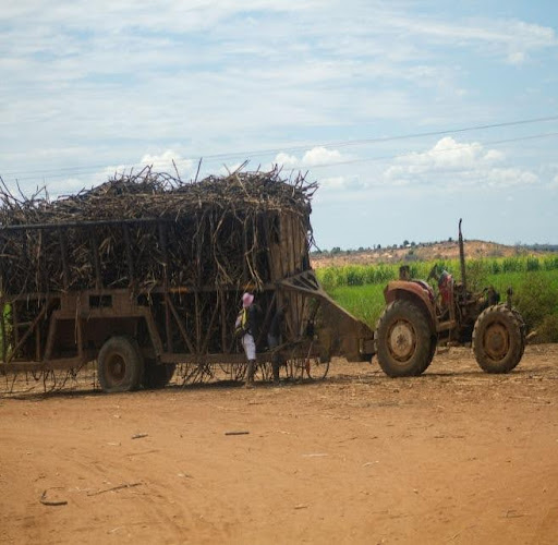
Figure 1: Sugarcane cultivation
Source: ARAKE
Moving inland from the coast, there is an increase in the cultivation of maize, cassava, sweet potatoes, legumes, as well as logging activities. Additionally, fishing and the exploitation of fishery resources represent a major economic activity throughout the area.
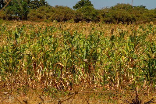
Figure 2: Maize cultivation
Source: ARAKE
However, the effects of climate change are becoming increasingly evident. Extreme weather events such as cyclones and floods occur more frequently, causing significant damage to crops, livestock, and fishing equipment—exacerbating poverty and food insecurity. Moreover, irregular rainfall often negatively affects agricultural yields
Throughout the year, the average temperature varies little and hovers around 28°C. August is the coolest month, with minimum temperatures around 22°C. October is the hottest month, with maximum temperatures reaching an average of 34°C. Mitsinjo typically experiences around 121 days of rainfall annually. June is the driest month with virtually no precipitation, while January is the wettest, with up to 415 mm of rainfall and 27 rainy days.
Flooding increases the risks of waterborne diseases and reduces access to clean drinking water and healthcare services. This is compounded by a limited number of healthcare personnel and facilities, the remoteness of certain localities, and access difficulties, which further worsen the health situation in the region.
To summarize, Mitsinjo regularly faces recurrent and severe flooding due to its fluvial and coastal geographic setting. The local population endures frequent displacements and significant threats to livelihoods, health, and infrastructure. The combination of unfavorable geographic and climatic conditions, inadequate and poor socio-economic and road infrastructure, and widespread poverty makes Mitsinjo a highly vulnerable area.